Arley Green
Appearance
| Arley Green | |
|---|---|
 | |
Location within Cheshire | |
| OS grid reference | SJ6880 |
| Shire county | |
| Region | |
| Country | England |
| Sovereign state | United Kingdom |
| Police | Cheshire |
| Fire | Cheshire |
| Ambulance | North West |
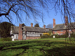
Arley Green is a hamlet in Cheshire, England, within the parish of Aston By Budworth.[1][2] The buildings originally formed Cowhouse Farm. Rowland Egerton-Warburton, the then owner of nearby Arley Hall, converted the half-timbered barn into a school in the 1830s and adapted another 18th-century building into a terrace of Tudor-style buildings. The farmhouse was converted into a parsonage.[3] All three buildings are Grade II listed.[4][5][6]
References
[edit]Wikimedia Commons has media related to Arley Green.
- ^ Ordnance Survey: Landranger map sheet 109 Manchester (Bolton & Warrington) (Map). Ordnance Survey. 2014. ISBN 9780319231555.
- ^ "Ordnance Survey: 1:50,000 Scale Gazetteer" (csv (download)). www.ordnancesurvey.co.uk. Ordnance Survey. 1 January 2016. Retrieved 30 January 2016.
- ^ Arley Hall and Gardens (guidebook), Jarrold Publishing, 1999.
- ^ Historic England. "Arley Green School and Arley Green Lodge (Grade II) (1139544)". National Heritage List for England. Retrieved 4 January 2023.
- ^ Historic England. "King's Cottage, Chaplains House, School House and Oak Lodge (Grade II) (1139545)". National Heritage List for England. Retrieved 4 January 2023.
- ^ Historic England. "The Old Parsonage (1329675)". National Heritage List for England. Retrieved 4 January 2023.

